#Central Cumberland Plateau
Explore tagged Tumblr posts
Visit Tumblr Blog
Explore Tumblr blogs with no restrictions, modern design and the best experience.
Last Seen Tumblr Blogs


Fun Fact
Tumblr has a 66 index score for customer satisfaction in the US.
Text
i love the south. the ozarks and ouachitas, the piney woods, southeast texas, the mid-south, the lower delta, cajun country, the cumberland plateau, the deep south, new orleans, central appalachia, the smokies, the piedmont, the gulf coast, chesapeake bay, the south atlantic plain, the outer banks, the carolina beaches, the lowcountry, all of north florida… i just love it here and i love being from here. i love how diverse an area it is with so many different cultural identities and yet we all have solidarity due to common struggles and experiences. it has a lot of issues, and we as southerners have a lot of work to do, but i’ll never give up on us and our home.
#southern#the south#ozarks#texarkana#houston#memphis#mississippi#cajun country#nashville#deep south#new orleans#appalachia#smoky mountains#piedmont#gulf coast#chesapeake#winston salem#outer banks#myrtle beach#lowcountry#north florida
33 notes
·
View notes
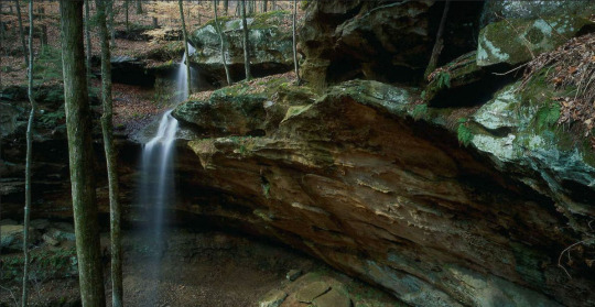
Photo

Lot 80 Long Branch Rd Spencer, TN 38585
Are you looking for a unique community of neighbors? Are you a hiker looking for trails that are close to home? This is a 3.29 AC wooded lot. Long Branch Lakes sits atop the Cumberland Plateau in Central Tennessee. Property boasts Waterfall and Wet Weather Creek running through. It is 3500 acres of Woodlands, Lakes, and Equestrian properties surrounded by 7000 acres of The Bledsoe State Forest and adjacent to Fall Creek Falls State Park. Amenities include fishing, hiking, kayaking, tennis, sports fields, and other outdoor activities. Property owners have access to the equestrian facilities. You will fall in love with this fire-wise community! Don't miss this opportunity to own your slice of heaven! Call Elijah Castelli 931-283-6644 for more details.
0 notes
Video

flickr
A Cave Ceiling Towering Above (Mammoth Cave National Park) by Mark Stevens Via Flickr: With this image I wanted to capture the sheer immenseness of the cave around me at this point of the Mammoth Passage Tour.
#Appalachian Mountains#Appalachian Plateaus#Audubon Avenue#Azimuth 131#Capture NX2 Edited#Cave Ceiling#Cave Walls#Central Cumberland Plateau#Color Efex Pro#Cumberland Plateau#Day 5#Giant Canyon Passage#Inside#International Biosphere Reserve#Landscape#Looking SE#Mammoth Cave National Park#Mammoth Passage Tour#Nature#Nikon D800E#Project365#Travel#Trip to Gateway Mammoth Cuyahoga National Parks#World Heritage Site#Kentucky#United States
4 notes
·
View notes
Text
American Auto Trail-Cincinnati Lookout Mountain Air-Line Highway (Bitter Creek to Harriman TN)
American Auto Trail-Cincinnati Lookout Mountain Air-Line Highway (Bitter Creek to Harriman TN) https://youtu.be/eqjbL1A_IO4

American Auto Trail-Cincinnati Lookout Mountain Air-Line Highway (Bitter Creek to Harriman TN)
In 1921, the Chattanooga Automobile Club organized the Cincinnati Lookout Mountain Air-Line Highway Association. This route was one hundred miles shorter than the Western Division of the Dixie Highway, connecting Cincinnati with Chattanooga through Somerset, Kentucky. Attempts…
View On WordPress
#american history#Cincinnati southern#Cumberland plateau#emory river#harriman#Historical#Honeycutt#landmark#lookout mountain#morgan county#oakdale#preservation#road travel#roane county#slow travel#tennessee#Tennessee central#walden ridge
0 notes
Photo


Meehania cordata
Meehan’s Heart Mint.
altough associated with core populations in Alleghany plat -Piedmont of the Appalachian Mountains, we see it often in sections of the Red in spots here and there all though the red is part of the ILP and is adjacent to the norther Cumberland plat section of the Appalachian mountains. This species was broken off from the scullcap genera a long time ago, it remains the only species in the genera and often is associated with a unique mesic forest habitat called Allegheny Plateau-Central Appalachian Acidic Seep Forest. Sections along rough trail near Military Wall are rich with this species, as it is, this also happens to be a well known population at the western most section of their range along Martin’s fork in Slade county and unique in it’s geographic placement.


15 notes
·
View notes
Text
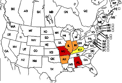
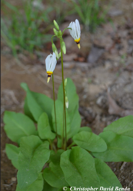
Biogeography of unique shade-loving, cliff-dwelling French’s shootingstar of the central hardoowds forests of North America, and its isolated presence in Alabama:
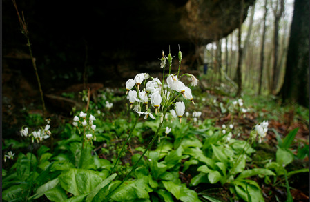
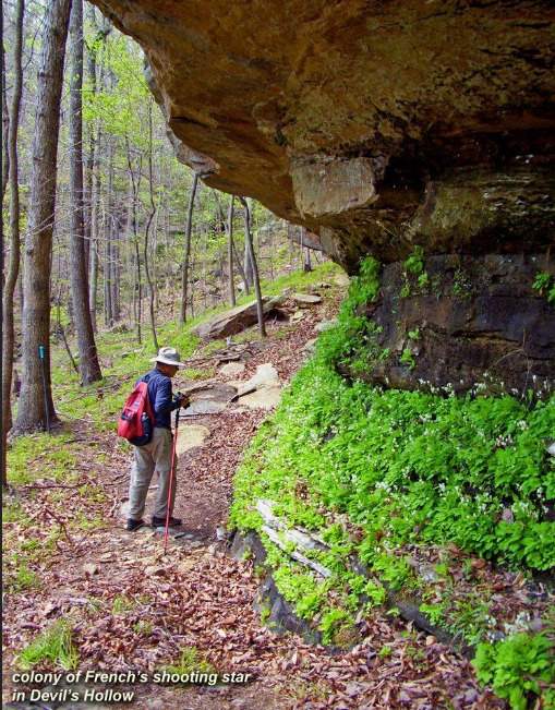
Photo 1: French’s Shootingstar - Dodecatheon frenchii - under a sandstone overhang in Shawnee National Forest, southern Illinois. (Source.) Photo 2: A colony of the plant in typical habitat under an overhang at Devil’s Hollow in Cane Creek Canyon Nature Preserve in Alabama. (Source.)
Text from R. Scot Duncan’s Southern Wonder: Alabama’s Surprising Biodiversity:
Within the deep canyons of Little Mountain is found French’s Shootingstar, a lovely little plant whose presence in northwestern Alabama is linked to an ancient coastline. Early each spring, the shootingstar emerges from dormancy and grows low to the ground. By late spring, older plants will develop a thin stalk several inches long on which hang several delicate flowers. At the base of each petal is a strip of deep maroon bordered in yellow, but the rest of the petal is an immaculate white turning pink with age. The flower strongly recurves its petals skyward while aiming its pistil and stamens downward. As the name suggests, the overall display could resemble a meteorite streaking earthward.
However, these shootingstars will never see the sky, for they live exclusively beneath the lip of sandstone overhangs provided by the Cumberland Acidic Cliff and Rockhouse ecosystem. Why the shootingstar lives here is clear: light is so scarce and the soils can be so dry that virtually no other vascular plants vie for this habitat. What’s more, the rockhouse protects the plants from erosion and being smothered by the thick mats of leaf litter accumulating on the forest floor just a few feet away. [...] How rockhouses came to be in [northern Alabama] takes us back to 340 million years ago [...] when [...] the area that is now the Southwestern Appalachians [...] was a shallow tropical sea. [...] Just offshore, sands accumulated as a chain of barrier islands like those along the Gulf Coast. This island chain became a thick rock formation dubbed the Harstelle Sandstone.
The Pride Mountain and Hartselle Sandstone formations breach the surface of northern Alabama in several locales, but nowhere as prominently as in the Little Mountain ecoregion of the Interior Plateau. [...] The dry, sandy soils on the caprock sustain the Southern Interior Low Plateau Dry-Mesic Oak Forest that was once widespread in [the Deep South’s interior plateau region]. [...] The most intriguing ecosystems of Little Mountain occupy the valleys and canyons weaving through these hills. These sheltered slopes harbor another variation of the [the Deep South’s wetter interior mesophytic forests] and hundreds of animals and plants rare elsewhere in the Southeast. Among them are orchids, lilies, azaleas, American Ginseng, Goldenseal, American Columbo, Bosch’s Filmy Fern, Eastern Leatherwood, and Kentucky Yellowood, to name a few. [...] There’s so much plant diversity that plant enthusiasts return to Little Mountain year after year. The rockhouse homes of French’s Shootingstar occupy the steepest slops of Little Mountains canyons. They form because [...] softer and lower rocks of Pride Mountain Formation erode first, while the upper and harder Harstelle Sandstone yields more slowly. These differential rates of erosion create the overhangs. [...]
French’s Shootingstar is known from Arkansas and four Midwestern states, but its presence in Alabama is a biogeographical puzzle. None of Alabama’s neighboring states have populations. What’s more, Alabama’s only population is on Little Mountain, despite the proximity of rockhouses a dozen miles away in the Dissected Plateau ecoregion. For whatever reason, this little plant survives in Alabama thanks to those barrier islands from long, long ago.
The Shooting Star Cliffs of Perry County and Crawford County, Indiana, featuring some ecological communities more similar to Appalachia rather than the “typical” Heartland. (Source.)
58 notes
·
View notes
Text
If any of y’all are in or from central TN/Nashville please let me know if you’re okay!! Could hear the signature tornado train-rumbling thunder from the other side of the Cumberland plateau last night 🙁
2 notes
·
View notes
Photo

A moody photo of Smith Lake in Arley, Alabama, taken this morning (February 9, 2023)... "Lewis Smith Lake (or Smith Lake) is located in North-Central Alabama about 20 miles northwest of Birmingham in state of Alabama (U.S.) counties of Cullman, Walker and Winston. The 300-foot high dam, completed in 1961 by Alabama Power Company, impounds the Sipsey Fork of the Black Warrior River to form the lake. Smith Lake has a surface area of 21,200 acres, 500 miles of shoreline, a watershed area of 944 square miles, a retention time of 435 days, and a maximum depth of 264 feet. The western side of the lake's watershed is crowned by the 180,000-acre Bankhead National Forest, which blankets the deeply dissected southern edge of the Cumberland Plateau. The Sipsey Fork of the Black Warrior River, Alabama's only Wild and Scenic River, flows through the Bankhead National Forest. The Sipsey Wilderness, Land of a Thousand Waterfalls, lies within the Bankhead National Forest and is home to Alabama's largest tree, a tulip poplar with a 21-foot circumference at its base." Via https://www.smithlake.info/ #sweethomealabama #rv #rvlife #rvliving #believe #camping #livinginanrv #rvtravel #ourcrazyrvlife #rvfulltime #fulltimerving #Christian #blessings #lifeontheroad #rvadventures #rvlivingfulltime #rvcamping #traveltrailerlife #rvcouple #prayer #love #faith #rvlifestyle (at Arley, Alabama) https://www.instagram.com/p/Coc47Ihubtr/?igshid=NGJjMDIxMWI=
#sweethomealabama#rv#rvlife#rvliving#believe#camping#livinginanrv#rvtravel#ourcrazyrvlife#rvfulltime#fulltimerving#christian#blessings#lifeontheroad#rvadventures#rvlivingfulltime#rvcamping#traveltrailerlife#rvcouple#prayer#love#faith#rvlifestyle
0 notes
Text
The Great Appalachian Mountain range of the USA and its Geology
Appalachian Mountains range
The Appalachian Mountains range is a series of mountain ranges that stretches from the eastern to the northeastern part of North America. The mountain is on the eastern side of the Rocky Mountains. The Appalachian Mountains extend for about 2896 km from the Central Alabama region in the United States to the Canadian province of Newfoundland and Labrador. These mountain ranges form a natural boundary between the eastern Coastal Plain and the Interior Lowlands of North America. The range is a popular tourist destination and is home to many ski resorts. The Appalachian Highland is also home to some of the most rugged terrain in the eastern United States and is known for forestry, farming and is home to many different types of wildlife.
Geology of the area
Appalachian Mountain Tectonic Plates are involved in the plate tectonics that makes up the Earth's crust. Mountains are regarded as the oldest mountain chain on the earth. Research revealed that mountains have been formed approximately 480 million years ago during the Ordovician period. At this time, the ancient Iapetus oceanic plate began to subduct beneath the North American Plate, leading to a period of mountain-building, known as Taconic orogeny, which resulted in the formation of the mountains Appalachian. Over the next 250 million years, the region experienced a series of mountain-building processes including the Alleghenian, Acadian, Caledonian, and Hercynian orogenies.
The southern and central regions of the Appalachian Mountains are known for their coal deposits mainly bituminous and anthracite coal. Petroleum, natural gas, and minerals like iron and zinc have also been found in the region.
Appalachian Mountains range has a deeply rugged topography due to fluvial action and Relatively low elevation, reaching its highest point on Mount Mitchell 2,037 m. Pleistocene glaciations evidence has been found in the northern part of the Appalachians, such as the Great Lakes. It is revealed in research that the Appalachians were initially as high as the Alps and the Rocky Mountains, but natural erosion eventually led to a reduction in the height of the mountains.
Sedimentary deposits in the Appalachian Range vary from Paleozoic rocks in the north to metamorphic and granite in the south (Blue Ridge). The features reveal that the Blue Ridge Mountains were formed before the northern part of the Appalachian Range. Appalachian Mountain system can be divided into three large physiographic regions. See the Appalachian Mountains Map.
North Applaiachian mountain stretches from the Newfoundland and Labrador province in Canada to the Hudson River in New York. The mountain ranges which are found in the northern region include the Annieopsquotch Mountains, Long Range Mountains, Chic-Choc Mountains, Green Mountains.
Central Applaiachian mountain
The central region extends from the Hudson valley to the new river which flows through the US states of Virginia, West Virginia, and North Carolina. The Central section includes the Taconic Mountains, The Great Appalachian Valley, The New York Jersey Highlands, and a Major part of the Blue Ridge Mountain.
South Appalachian mountain range
The southern section includes the Cumberland Plateau, the Ridge and Valley Appalachians, and the rest of the Blue Ridge Mountains. The highest mountain peaks in the southern section of the Appalachians include the peaks of the Black Mountains in North Carolina and the Smoky Mountains of Tennessee and North Carolina.
Famous mountain ranges in Applaiachian
Smoky Mountains
The Smoky Mountains consist of Layers of limestone that were added to already existing sedimentation at the beginning of the mountain formations around 300 million years ago. The mountain structures grew to great elevation with the shifting and tilting of the underlying metamorphic rock. Erosion plays important role in the formation of mountains. Most of the rocks in the Smoky Mountains date to the Precambrian Age.
Also read- The Spectacular Niagara Waterfalls and its Geology
Blue Ridge Mountains
The Blue Ridge is of the Appalachian Mountains range remarkably uniform in shape and elevation. The Blue Ridge Mountains have a crystalline foundation and its basement comprises gneiss and schist transformed from volcanic rock. This indicates that volcanic flow may have been partly responsible for the formation of these mountains.
Appalachian mountain trail
The Appalachian Mountain Trail is a 2400 km hiking trail that runs from Georgia to Maine. The Appalachian Mountains are made up of many different types of rocks and are some of the oldest mountains in the world. The Trail is a long and difficult hiking trail and one of the most beautiful trails in the United States.
See more- Geotourism
1 note
·
View note
Photo
I, uh, never noticed the fact that it’s a Chattanooga news van before now...which means it’s supposed to be very close to where I grew up, holy shit. I knew it was in TN, obviously, but damn. TN’s a fairly big state (for context, at 60-70mph, it takes my family on the southern border of TN 45 min to get to Chattanooga, the nearest big city, and 1hr 30min to get to Nashville, the capital and a central-ish city of the state—Memphis, the westernmost city that you’d have heard of, is ~5hrs), but if it’s a Chattanooga station instead of a Nashville one or a Knoxville one, the fictional ‘Rose Hill’ has got to be in the Cumberland Plateau/TN River Valley area. Which is very rural, sparsely populated, and a weird mixture of deeply impoverished counties and rich Nashvillians’ weekend mountain homes. Just a bit of context that makes this part of the movie make a little more sense to me.


“He’s not thinking straight”
#huh#this gives me a reason to go back and watch it again#time to play rural TN bingo!#mcu#iron man#TN
3K notes
·
View notes
Photo

Monday, March 27, 1967
As the air war continued, United States pilots shot down the 38th MIG jet over North Vietnam, but enemy gunners in South Vietnam brought down seven American helicopters. During the attack on a supply depot 23 miles west of Hanoi, U.S. pilots said they destroyed three warehouses and set fire to another building.
A mood of anger appears to be spreading along the ridges of the Cumberland plateau, and according to many observers, a sense of militancy is replacing the traditional apathy among the people in the heartland of Appalachian poverty. What some have called the beginning of a “rural revolution" has spread along the Cumberland Mountain range in eastern Kentucky, southwestern Virginia and southern West Virginia.
Gov. Richard J. Hughes of New Jersey has been named chairman of the Democratic National Committee’s Special Equal Rights Committee, where part of his assignment will be the sensitive political job of drafting a plan to insure fair Negro representation at the Democratic Convention in 1968.
Republican advisers to George Romney of Michigan are split over whether the Governor should become a hawk or a dove on the issue of Vietnam. At stake in the decision are Mr. Romney’s chances for winning the Presidential nomination and the question of whether the G.O.P. will try to make Vietnam an issue at all in the 1968 election.
From dawn to dusk, a crowd of more than 10,000 wandered through the Sheep Meadow in Central Park for a noisy, chaotic and surrealistic “Be-In.”
#1960s#1967#1968 democratic convention#60s#air war#appalachia#be-in#central park#central park be-in#counterculture#george romney#hippies#military action#sixties#summer of love#vietnam war#1968 presidential election
2 notes
·
View notes
Text
The Okra Illuminati
“Artemis Rat Okra” aka V.E.G. Ham.
Let me introduce Van Eugene Gatewood Ham, a native of Greenville, Mississippi, with a soft spot for okra.
Gene Ham visits Central Kentucky every Thanksgiving to catch up with childhood friends who live nearby. He came to our home last year for a Friday evening party. A small pile of crispy okra seedpods, the color of dried parchment, sitting on the kitchen counter, caught his eye. He recognized the seedpods immediately. I was impressed. Okra seedpods would stump most folks on an ID quiz, even savvy horticulturists.
I asked Gene if he was an okra fan. He held the seed pods tenderly, glanced knowingly, turned serious, and unwound—slowly—“Oh, yeah.”
Gene figured correctly. I love okra, also.
He looked around.
He did not want to be overheard. “Do you have time for a story?” Gene’s a storyteller. He began sketching details about the origins and history of the Knights and United Daughters of Okra.
Where, exactly, any of this story took place, Gene wouldn’t tell me. There were references to Southwest Virginia and the Cumberland Plateau, but who knows?
The outline was a doozy, but pieces were missing. His story was not a tell-all. Gene did not want to betray his brethren and sisterhood.
I’d had second helpings of skillet-fried okra on the brain for months, wondering about Gene’s story, and then I read the wonderful Walks to the Paradise Garden—A Lowdown Southern Odyssey.
Gene’s name was in the book’s acknowledgements—in code!
‘”Artemis Rat Okra” aka V.E.G. Ham.”’
Turns out, Gene was a player in this southern odyssey by virtue of okra, though, no doubt also a participant in conversations about all manner of things, besides okra, among friends and colleagues who were also acknowledged.
Jonathan Williams, the late poet and “provocateur,” laid out the project’s intent in the book’s introduction. “For one thing, most of the people (folk artists) in this book are directly involved with making paradise for themselves in the front yard, the back garden, the parlor, the sun porch, the basement. Making things has been a way to salvage a little dignity from poor and difficult lives.” Later on, Williams wrote clearly and proudly: These are “visionaries, eccentrics and treasures.”
“Walks in the Paradise Garden, “Williams explains, “is not Kunsthistorichwerk, or criticism, or sociology or anthropology, or camp for the coffee table. It is a collection of outlandish findings by three southern persons, all white and all male. This is something we don’t fret about and hope that you won’t either. May we please both okra-eaters and non-okra-eaters alike!”
Jonathan Williams and photographers Roger Manley and Guy Mendes drove around the south in the 1970s until the early 1990s, attempting to meet and document outsider artists.
The next meal was never far away. There were breakfasts of beaten biscuits and country ham, pecan waffles and grits. (Grits lost ground briefly to polenta in uppity southern restaurants in the 1990s but survived the cultural skirmish.) There were odyssey dinners (lunchtime) and suppers (dinners) with barbecue, catfish, turnip greens, fried chicken, sweet potato casserole and, of course, okra.
The Lowdown Southern Odyssey project lay dormant for years but was not forgotten. Walks in the Paradise Garden was published by Institute 193, this spring, at long last, accompanied by an exhibit at Atlanta’s High Museum.
Sister Gertrude Morgan in her Everlasting Gospel Revelation Mission, New Orleans, LA, 1974. Guy Mendes photo. Courtesy of the artist and Institute 193.
Back to Gene Ham.
I wrote Gene (he doesn’t use a computer) a few months ago, after I read the wonderful Walks to the Paradise Garden. I hoped Gene would school me on okra and Okra Memorial University. Gene, by the way, is a retired English teacher who lives now in Fayetteville, Tennessee.
A few weeks went by before a finely written letter arrived. “As is typical of other fraternal and sororal orders there are mysteries which can not be revealed…like the nearly lost origins of Free Masons in the distant past.”
One point was clear: “Then, as now, members were bound together by a love of the divine vegetable. Several of the generals were exiles from the deeper south who were greatly dismayed at the absence of okra in local produce markets.”
Gene Ham allowed that Okra Memorial University, and its pop-up satellite affiliates—wherever, or if they were ever—have on occasion, granted degrees that are “chiefly honorary.” Doctorates have been conferred on Wendell Berry, Allen Ginsburg and Ken Kesey in “simple but significant ceremonies over the years.”
https://www.gardenrant.com/wp-content/uploads/2019/08/Gene-Ham-Roy-Blount-Jr.-Okra-080719.mp3
Listen to Gene Ham recite Roy Blount Jr.’s Song to Okra.
This is the scantest little I know of the mythic Okra Illuminati.
Good luck if you try to Google The Knights and United Daughters of Okra.
I was in my early 20s before I first tasted okra. I was smitten, and I’ll admit: I have an inherited taste for greasy food. I can’t, however, explain why, or how, delectably, slimy okra had been hidden from me for so many years.
(For anyone willing to explore okra’s history, culture, sociology, recipes (not all greasy), seed strains and, yes, tips on “mucilaginous” hair conditioner, I recommend, also: The Whole Okra—A Seed to Stem Celebration.)
Gene Ham likes okra the simple way: boiled with a little bit of butter and black pepper. Or Creole style: fried with okra cut crosswise along with tomatoes, green pepper, onions, and garlic,laid on a bed of rice.
Not everyone can be blessed with Gene Ham’s good taste.
Please, no more okraphobic slurs of cotton’s cousin.
Set your taste buds free.
The Okra Illuminati originally appeared on GardenRant on August 14, 2019.
from Gardening https://www.gardenrant.com/2019/08/the-okra-illuminati.html via http://www.rssmix.com/
0 notes
Video

flickr
Rain Fed Water Fall into Mammoth Cave at the Historic Entrance View (Mammoth Cave National Park) by Mark Stevens Via Flickr: A portrait orientation of an image from just inside the main, historic entrance in this part of Mammoth Cave National Park with a view looking to just outside the cave. While most of the images at this point had been with a landscape orientation, I felt a portrait one would best capture that feel of the cave entrance, especially with the waters falling from the top to some nearby rocks a little to my front. I decided to go with a longer exposure in order to bring out more of a milkier look to the falling waters. I then worked with Capture NX2 and used some D-Lighting adjustments to bring out the more shadowed areas without including too much color cast. I later did some work with color control points for the final image seen.
#Appalachian Mountains#Appalachian Plateaus#Azimuth 339#Capture NX2 Edited#Cave Entrance#Cave Opening#Central Cumberland Plateau#Color Efex Pro#Cumberland Plateau#Day 5#Historic Entrance#International Biosphere Reserve#Landscape#Lichen on Rocks#Looking NW#Mammoth Cave National Park#Mammoth Passage Tour#Nature#Nikon D800E#Outside#Overcast#Portfolio#Project365#Small Waterfall#Travel#Trees#Trip to Gateway Mammoth Cuyahoga National Parks#Waterfall at Entrance#World Heritage Site#Kentucky
2 notes
·
View notes
Text
The Okra Illuminati
“Artemis Rat Okra” aka V.E.G. Ham.
Let me introduce Van Eugene Gatewood Ham, a native of Greenville, Mississippi, with a soft spot for okra.
Gene Ham visits Central Kentucky every Thanksgiving to catch up with childhood friends who live nearby. He came to our home last year for a Friday evening party. A small pile of crispy okra seedpods, the color of dried parchment, sitting on the kitchen counter, caught his eye. He recognized the seedpods immediately. I was impressed. Okra seedpods would stump most folks on an ID quiz, even savvy horticulturists.
I asked Gene if he was an okra fan. He held the seed pods tenderly, glanced knowingly, turned serious, and unwound—slowly—“Oh, yeah.”
Gene figured correctly. I love okra, also.
He looked around.
He did not want to be overheard. “Do you have time for a story?” Gene’s a storyteller. He began sketching details about the origins and history of the Knights and United Daughters of Okra.
Where, exactly, any of this story took place, Gene wouldn’t tell me. There were references to Southwest Virginia and the Cumberland Plateau, but who knows?
The outline was a doozy, but pieces were missing. His story was not a tell-all. Gene did not want to betray his brethren and sisterhood.
I’d had second helpings of skillet-fried okra on the brain for months, wondering about Gene’s story, and then I read the wonderful Walks to the Paradise Garden—A Lowdown Southern Odyssey.
Gene’s name was in the book’s acknowledgements—in code!
‘”Artemis Rat Okra” aka V.E.G. Ham.”’
Turns out, Gene was a player in this southern odyssey by virtue of okra, though, no doubt also a participant in conversations about all manner of things, besides okra, among friends and colleagues who were also acknowledged.
Jonathan Williams, the late poet and “provocateur,” laid out the project’s intent in the book’s introduction. “For one thing, most of the people (folk artists) in this book are directly involved with making paradise for themselves in the front yard, the back garden, the parlor, the sun porch, the basement. Making things has been a way to salvage a little dignity from poor and difficult lives.” Later on, Williams wrote clearly and proudly: These are “visionaries, eccentrics and treasures.”
“Walks in the Paradise Garden, “Williams explains, “is not Kunsthistorichwerk, or criticism, or sociology or anthropology, or camp for the coffee table. It is a collection of outlandish findings by three southern persons, all white and all male. This is something we don’t fret about and hope that you won’t either. May we please both okra-eaters and non-okra-eaters alike!”
Jonathan Williams and photographers Roger Manley and Guy Mendes drove around the south in the 1970s until the early 1990s, attempting to meet and document outsider artists.
The next meal was never far away. There were breakfasts of beaten biscuits and country ham, pecan waffles and grits. (Grits lost ground briefly to polenta in uppity southern restaurants in the 1990s but survived the cultural skirmish.) There were odyssey dinners (lunchtime) and suppers (dinners) with barbecue, catfish, turnip greens, fried chicken, sweet potato casserole and, of course, okra.
The Lowdown Southern Odyssey project lay dormant for years but was not forgotten. Walks in the Paradise Garden was published by Institute 193, this spring, at long last, accompanied by an exhibit at Atlanta’s High Museum.
Sister Gertrude Morgan in her Everlasting Gospel Revelation Mission, New Orleans, LA, 1974. Guy Mendes photo. Courtesy of the artist and Institute 193.
Back to Gene Ham.
I wrote Gene (he doesn’t use a computer) a few months ago, after I read the wonderful Walks to the Paradise Garden. I hoped Gene would school me on okra and Okra Memorial University. Gene, by the way, is a retired English teacher who lives now in Fayetteville, Tennessee.
A few weeks went by before a finely written letter arrived. “As is typical of other fraternal and sororal orders there are mysteries which can not be revealed…like the nearly lost origins of Free Masons in the distant past.”
One point was clear: “Then, as now, members were bound together by a love of the divine vegetable. Several of the generals were exiles from the deeper south who were greatly dismayed at the absence of okra in local produce markets.”
Gene Ham allowed that Okra Memorial University, and its pop-up satellite affiliates—wherever, or if they were ever—have on occasion, granted degrees that are “chiefly honorary.” Doctorates have been conferred on Wendell Berry, Allen Ginsburg and Ken Kesey in “simple but significant ceremonies over the years.”
https://www.gardenrant.com/wp-content/uploads/2019/08/Gene-Ham-Roy-Blount-Jr.-Okra-080719.mp3
Listen to Gene Ham recite Roy Blount Jr.’s Song to Okra.
This is the scantest little I know of the mythic Okra Illuminati.
Good luck if you try to Google The Knights and United Daughters of Okra.
I was in my early 20s before I first tasted okra. I was smitten, and I’ll admit: I have an inherited taste for greasy food. I can’t, however, explain why, or how, delectably, slimy okra had been hidden from me for so many years.
(For anyone willing to explore okra’s history, culture, sociology, recipes (not all greasy), seed strains and, yes, tips on “mucilaginous” hair conditioner, I recommend, also: The Whole Okra—A Seed to Stem Celebration.)
Gene Ham likes okra the simple way: boiled with a little bit of butter and black pepper. Or Creole style: fried with okra cut crosswise along with tomatoes, green pepper, onions, and garlic,laid on a bed of rice.
Not everyone can be blessed with Gene Ham’s good taste.
Please, no more okraphobic slurs of cotton’s cousin.
Set your taste buds free.
The Okra Illuminati originally appeared on GardenRant on August 14, 2019.
from GardenRant https://ift.tt/2YUt4Ax
0 notes
Photo

Interior Low Plateaus’ Cave alumroot near dormant state.
Heuchera parviflora var. parviflora
couldn’t help stopping by this population for fun
this species var. is only found in the sub region of the Appalachian mountains ranging from the Ohio River Valley down through Dan Boone into the Cumberland Gap passing the cedar barrens of central TN basin into Alabama dolomites and sandstone hills known as the Interior Low Plateaus.
this specific photo is from Red River Gorge, Ky
The Interior Low Plateaus are a remnant of upheval events caused by several arch events that caused secondary mountain formation along the foothills of the Appalachian mountains. This fraction of ecoregion is usually lumped into the Interior Centeral Lowlands due to glacial events being it’s primary cause.
The core of this section where the upheavals, dome deformation, and glacial weathering events have occurred in their own stratification really seem like they are a hotspot for these biological variation and local endemism events ( its honestly the part of Appalachia I am most enamored by because of how unusual it is.)
As you may know, the Interior lowlands of the North were pretty much smacked by the Wisconsin glaciation,Illinoisan glaciation, and of course the Pre Illinoisan glaciation which caused the upper prairie peninsula in Appalachia; but, it did little compared to the outwash and deposition events following the true glaciation events of the Pleistocene epoch and the rebounding and upheaval that caused glacial lakes to be depleted, platuelands to be formed, and dome formation/ depletion that followed.

Refugiums and bare rocks penetrated by prairie and Pleistocene ripperian forests in the forms of sandstone/ lime/dolostone gorges, cedar glades, and fragipan enforced fens in these regions were set into motion to eventually have population isolation events and high levels to low levels of endemism occurrences.

This region of upheaval caused by the Cincinnati arch and the upper flanks of Findlay Arch and Kankakee arches which caused the creation of the Nashville dome and its degeneration is the very same that caused the upheaval of semi concreted sandstone from preillinoisan outwash and the upheaval of the nearly to completely horizontal beds of Paleozoic sandstone, shales, and calcareous sedimentary rocks. These are the Interior Low Plateaus
The limestone of the province is marked by well-developed karst topography which can be seen in many different forms of formation, undercutting, talussing , and water weathering. Mammoth Cave National Park is considered one such location where all forms of calcareous karst formation seem to be present in some shape and form. There are even some subsurface tavertine exposures. When it comes to Sandstone formations I may be a bit biased to Red River Gorge, but many locations exist with sandstone cliff endemism.
.
91 notes
·
View notes
Text
A Tourist Guide to West Virginia
Stand Out – Be Seen – Be On Google Page 1 Before You Pay For Services – CLICK HERE! We call it RBI Marketing. You have heard of ROI which is Return On Investment and this is RBI which means Return BEFORE Investment! Let’s get the ball rolling and you will pay us for our services AFTER you see your site ranked on Google page 1 for your chosen keywords!.CLICK HERE!
***********
We are always on the lookout to hire quality, professional independent representatives for our local business pay per result search engine optimization services. Just use the form on the home page to contact us!
************
1. INTRODUCTION
West Virginia, endlessly covered with forests and known as the “Mountain State,” offers breathtaking scenery, natural resource-related sights, and year-round, outdoor activities.
Once rich in coal and timber, it was shaped by the mines and logging railroads which extracted them, but when decades of removal began to deplete these commodities, their rolling, green-carpeted mountains yielded secondary byproducts-namely, hiking, biking, fishing, rafting, climbing, and hunting to tourists and sports enthusiasts alike. Its New River Gorge, which offers many similar activities, is equally beautiful with its rugged banks and azure surfaces, while the principle city of Charleston, revitalized during the 1970s and 1980s, now features museums, art, shopping malls, restaurants, and world-class performance venues.
2. CHARLESTON
Located on the Kanawha River, and sporting an easily negotiable street grid system, it is subdivided into the Capitol Complex and the downtown area with the East End Historic District linking the two.
From the former, which is the heart of state government, juts the ubiquitously visible, gold-domed Capitol Building itself. Constructed of buff Indiana limestone and 4,640 tons of steel, which themselves required the temporary laying of a spur rail line to transport them, the building had been laid in three stages during an eight-year period: 1924 to 1925 for the west wing, 1926 to 1927 for the east wing, and 1930 to 1932 for the connecting rotunda. It was officially dedicated by Governor William G. Conley on June 20, 1932, on the occasion of West Virginia’s 69th birthday as a state.
Its gold dome, which extends five feet higher than that of the Capitol in Washington, is gilded in 23 ½-karat gold leaf, applied between 1988 and 1991 as tiny squares to cover the otherwise copper and lead surface.
Two-thirds of its interior, which encompasses 535,000 square feet subdivided into 333 rooms, is comprised of Italian travertine, imperial derby, and Tennessee marble, and the chandelier in the rotunda, its center piece, is made of 10,180 pieces of Czechoslovakian crystal illuminated by 96 light bulbs. Weighing 4,000 pounds, it hangs from a 54-foot brass and bronze chain.
Across from the State Capitol, but still within the complex, is the West Virginia Cultural Center. Opened in 1976 and operated by the West Virginia Division of Culture and History, it was created to showcase the state’s artistic, cultural, and historical heritage, and houses the West Virginia State Museum, the archives and history library, a gift shop, and a venue for cultural events, performances, and related programs.
The former, a collection of items which represents the state’s land, people, and culture, is subdivided into 24 significant scenes covering five periods: Prehistory (3 million years BC to 1650 AD), Frontier (1754-1860), the Civil War and the 35th State (1861 to 1899), Industrialization (1900 to 1945), and Change and Tradition (1954 to the 21st century). The 24 representations themselves trace the state’s evolution and include such periods as “Coal Forest,” “River Plains,” “Wilderness,” “The Fort,” “Harper’s Ferry,” “Building the Rails,” “Coal Mine,” “Main Street, West Virginia,” and “New River Gorge.”
Thirteen monuments, memorials, and statues honoring West Virginians for their contributions to the state and the nation grace the Capitol Complex’s landscaped grounds.
Culture can also be experienced at the Clay Center for the Arts and Sciences, a modern, 240,000-square-foot, three-level complex which opened on July 12, 2003 and represents one of the most ambitious economic, cultural, and educational projects in West Virginia’s history. Offering sciences, visual arts, and performing arts under a single roof, the center houses the dual-level Avampato Discovery Museum, an interactive, youth-oriented experience with sections such as Health Royale, KidSpace, Earth City, and Gizmo Factory. A 9,000-square-foot Art Gallery, located on the second floor, features both temporary and permanent exhibits, the latter emphasizing 19th and 20th century art by names such as Andy Warhol, Stuart Davis, Alexander Calder, Frank Stella, Vida Frey, and Albert Paley. The ElectricSky Theater, a 61-foot domed planetarium, offers daily astronomy shows and wide screen presentations. Live performances are staged in two locations: the 1,883-seat Maier Foundation Performance Hall, which is home to the West Virginia Symphony Orchestra, but otherwise offers a variety of performance types, from comedy to popular singers, bands, repertory, and Broadway plays, and the 200-seat Walker Theater, which features plays and dances with cabaret-style seating for the Woody Hawley singer-songwriter program. The Douglas V. Reynolds Intermezzo Café and three classrooms are located on the lower level.
Shopping can be done at two major venues. The Charleston Town Center Mall, located adjacent to the Town Center Marriott and Embassy Suites Hotel, and near the Civic Center, is a one million square foot, tri-level complex with more than 130 stores, three anchor department stores, six full-service restaurants, and a food court with ten additional fast food venues, and is accessed through three convenient parking garages. Sporting a three-story atrium and fountain, the upscale, Kanawha Valley complex was the largest urban shopping center east of the Mississippi River when it opened in 1983.
The Capitol Market, located on Capitol and Sixth Streets in the restored and converted, 1800s Kanawha and Michigan Railroad depot, is subdivided into both in- and outdoor markets, the latter of which can only be used by bona fide farmers and receives daily, fresh, seasonal deliveries, usually consisting of flowers, shrubs, and trees in the spring; fruits and vegetables in the summer; pumpkins, gourds, and cornstalks in the fall; and Christmas trees, wreaths, and garlands in the winter. The indoor market sells seafood, cheeses, and wines, and offers several small food stands and a full-service Italian restaurant.
An evening can be spent at the TriState Racetrack and Gaming Center. Located a 15-minute drive from Charleston in Cross Lanes, the venue offers 90,000 square feet of gaming entertainment, inclusive of more than 1,300 slot machines, live racing, a poker room, blackjack, roulette, and craps, and four restaurants: the French Quarter Restaurant and Bar, the First Turn Restaurant, the Café Orleans, and Crescent City.
3. POTOMAC HIGHLANDS
The Potomac Highlands, located in the eastern portion of the state on the Allegheny Plateau, is a tapestry of diverse geographic regions and covers eight counties. Alternatively designated “Mountain Highlands,” it had been formed some 250 million years ago when the North American and African continental collision had produced a single, uplifted mass. Subjected to millennia of wind- and water-caused erosion, it resulted in successive valleys and parallel ridges, and today the area encompasses two national forests: Canaan Valley, the highest east of the Mississippi River, and Spruce Knob, at 4,861 feet, West Virginia’s highest point. Its green-covered mountains yielded abundant timber, the logging railroads necessary to harness it, two premier ski resorts, and a myriad of outdoor sports and activities.
The Potomac Highlands can be subdivided into the Tygart Valley, Seneca Rocks, Canaan Valley, and Big Mountain Country.
A. Tygart Valley
The town of Elkins, located in the Tygart Valley, is the transportation, shopping, and social center of the east central Appalachian Mountains and serves as a base for Potomac Highland excursions.
Established in 1890 by Senators Henry Gassaway Davis and Stephen. B. Elkins, his son-in-law and business partner, it originated as a shipping hub for their coal, timber, and railroad empire, the latter the result of their self-financed construction of the West Virginia Central Railroad, whose track stretched between Cumberland, Maryland, and Elkins, and served as the threshold to some of the world’s richest timber and mineral resources.
The town, serving the needs of the coal miners, loggers, and railroad workers, sprouted central maintenance shops and steadily expanded, peaking in 1920, before commencing a resource depletion-caused decline, until the last train, carrying coal and timber products to the rest of the country, departed the depot in 1959.
The tracks lay barren and unused for almost half a century until 2007, when the newly-established Durbin and Greenbrier Valley Railroad again resurrected them-and the town-transporting the first tourists for scenic-ride purposes and resparking a slow growth cycle with a subsequently built restaurant and live theater in its historic Elkins Railyard and additional hotels nearby. Consistently ranked as one of the country’s best small art towns, it is once again the service hub of the Mountain Highlands, reverting to its original purpose of providing hotel, restaurant, shop, and entertainment services, but now to a new group-tourists.
The railroad remains its focus. The Durbin and Greenbrier Valley Railroad offers three departures from the Elkins depot. The first of these, the “New Tygart Flyer,” is a four-hour, 46-mile round-trip run which plunges through the Cheat Mountain Tunnel, passes the towns of Bowdon and Bemis, parallels the Shavers Fork of the Cheat River, and stops at the horseshoe-shaped High Falls of Cheat, during which time it serves an en route, buffet luncheon. Upgraded table service is available in 1922-ear deluxe Pullman Palace cars for a slightly higher price.
The “Cheat Mountain Salamander” is a nine-hour, 128-mile round-trip to Spruce, and includes a buffet lunch and dinner, while the “Mountain Express Dinner Train” mimics the New Tygart Flyer’s route, but features a four-course meal in a formally set dining car.
The Railyard Restaurant, sandwiched between the Elkins depot and the American Mountain Theater, provides all on board meals. Emulating the depot itself with its exterior brick construction, the $2.5 million, 220-seat restaurant, leased to the Durbin and Greenbrier Valley Railroad, serves family-style cuisine on its main level and upscale dinners in its second-floor Vista Dome Dining Room, its menus inspired by railroad car fare from the 1920s to the 1940s. It toted the opening slogan of, “Take the track to the place with exceptional taste.”
The Durbin and Greenbrier Valley Railroad’s Rails and Trails Gift Shop is located on its main level.
Continuing the historic, red brick exterior, the adjacent American Mountain Theater, founded in 2003 by Elkins native and RCA recording artist, Susie Heckel, traces its origins to a variety show performed for tourists at a different location. But increasing demand merited the November, 2006, ground-braking for a $1.7 million, 12,784-square-foot, 525-seat structure with aid from her sister, Beverly Sexton, and her husband, Kenny, who owned the Ozark Mountain Hoe-Down Theater in Eureka Springs, Arkansas.
Opening the following July, the theater offered family-oriented, Branson-style entertainment performed by a nine-member cast, with Kenny Sexton serving as its president and producer and Beverly writing the score. Two-hour evening shows include comedy, impressions, and country, gospel, bluegrass, and pop music.
Davis and Elkins College, located only a few blocks from the Historic Railyard, shares the same founders as the town of Elkins itself-namely, Senators Henry Gassaway Davis and Stephen B. Elkins. Established in 1901 when they donated land and funding to create a college associated with the Presbyterian Church, it was originally located south of town. Its Board of Trustees first met the following year and classes were first held on September 21, 1904.
Today, the coeducational, liberal arts college, located on a 170-acre hilled, wooded campus with views of the Appalachian Mountains, is comprised of 22 new and historic buildings in two sections-the north, which stretches to the athletic fields and the front campus, which is located on a ridge overlooking Elkins. Thirty associate and baccalaureate arts, sciences, pre-professional, and professional degree programs are offered to a 700-student base.
One of its historic buildings is Graceland Inn. Designed by the Baltimore architectural firm of Baldwin and Pennington, the castle-like, Queen Anne-style mansion, originally located on a 360-acre farm, was completed in 1893. Initially called “Mingo Moor,” and intermittently “Mingo Hall” after the area south of Elkins, the estate served as the summer residence of Senator Davis, who regularly transported a train of invited friends and associates during July and August so that they could escape the Washington heat and enjoy Elkins’ higher-elevation, cooler temperatures.
The estate was ultimately renamed “Graceland” after Davis’ youngest daughter, Grace. Following his wife’s death in 1902, he continued to conduct business from offices inside it, while Grace herself resided there during the summer months with her family.
The estate was finally ceded to her own children, Ellen Bruce Lee and John A. Kennedy, its last two owners.
Acquired by the West Virginia Presbyterian Education Fund in 1941, it was used as a male residence hall by the college until 1970, whereafter it was closed. Restored during the mid-1990s, it subsequently reopened as an historic country inn and as a dynamic learning lab for hospitality students.
Overlooking the town of Elkins, on the Davis and Elkins College campus, Graceland Inn, listed on the National Register of Historic Places, features a two-story great hall richly decorated with hardwoods, such as quartered oak, bird’s eye maple, cherry, and walnut, a grand staircase, a parlor, a library, and its original stained glass windows. The Mingo Room Restaurant, reflecting the mansion’s initial designation and open to the public, is subdivided into four small rooms lined with red oak and fireplaces and an outdoor verandah, and eleven guest rooms, located on the second and third floors and named after prominent family members, contain antiques, canopy beds, armoires, marble bathrooms, and claw foot tubs.
Graceland Inn, the David and Elkins College, the town of Elkins itself, the historic depot and railyard, their tracks, and the Appalachian Mountain’s coal and timber resources are all inextricably tied to the town’s past–and its future.
B. Seneca Rocks
“Seneca Rocks” designates both a region of the Potomac Highlands and the outcroppings after which that region is named.
Resembling a razor back, or shark’s fin, and located at the confluence of the Seneca Creek and the North Fork South Branch Potomac River, the 250-foot-thick, 900-foot-high Seneca Rocks, accessible by West Virginia Route 28, were formed 400 million years ago during the Silurian Period in an extensive sand shoal at the edge of the ancient Iapetus Ocean. As the seas decreased in size, the rock uplifted and folded, erosion ultimately wearing away its upper surface and leaving the arching folds and craggy profile they exhibit today.
Made of white and gray tuscarora quartzite, the formation features both a north and south peak, with a notch separating the two.
The current Seneca Rocks Discovery Center, which replaced the original visitor’s center, features relief models of the area, films, interpretive programs, and a bookshop.
A path leads to the Sites Homestead, part of the center. Constructed in 1839 by William Sites as a single-room log cabin below Seneca Rocks Ridge, it is typical of then-current Appalachian homes whose German Blockbau-style featured square logs and v-notched corner joints spread apart by stone and clay chinks.
In the late-1860s, one of Sites’ sons expanded the homestead, adding a second floor, and, after use as a hay barn, the Forest Service purchased it in 1969, restoring it during the 1980s. In 1993, it was added to the National Register of Historic Places.
The greater Spruce Knob-Seneca Rocks National Recreation Area, offering significant outdoor sports opportunities, contains a key portion of the Chesapeake Bay watershed, whose mountains and forests collect water which then flows into the Potomac River and the bay itself. Acting as a cleansing and filtering mechanism, its headwater forests purify the water before it reaches the streams. Spruce Knob is both the highest point in the Chesapeake Watershed and the entire state of West Virginia.
Aside from facilitating water, the area has provided sustenance to humans, who first lived in Native American villages within its mountains, and then created farming settlements and logging camps, extracting its resources and supporting life for some 13,000 years. Today, it is home to 15 million people.
The Spruce Knob-Seneca Rocks National Recreation Area itself is part of the much larger Monongahela National Forest. Established in 1920 with an initial 7,200 acres, the present 910,155-acre forest contains the headwaters of the Monongahela, Potomac, Greenbrier, Elk, Tygart, and Gauley Rivers; five federally-designated “wildernesses”-Dolly Sods, Outer Creek, Laurel Fork North, Laurel Fork South, and Cranberry-whose very remote and primitive areas only offer lower-standard trail markings; and four lakes.
A Mecca for outdoor sports enthusiasts, the national forest features 169 hiking, biking, and horseback riding trails which cover more than 800 miles, 576 miles of trout streams, 129 miles of warm-water fishing, 23 campgrounds, 17 picnic areas, and wildlife viewing of black bear, wild turkey, white-tailed deer, gray fox, rabbits, snowshoe hare, grouse, and woodcock.
C. Canaan Valley
Blanketed with bigtooth aspen, balsam fir, and spruce, Canaan Valley, stretching 14 miles, is the highest such valley east of the Mississippi River, its namesake mountain separating it from the Blackwater River and creating a deep, narrow canyon in the Allegheny Plateau.
The pristinely beautiful area encompasses two state parks-Canaan Valley Resort and Black Water Falls State Parks; two ski areas-again Canaan Valley Resort and Timberline Four Seasons Resort; and the nation’s 500th wildlife refuge.
Natural sports abound: hiking, horseback riding, fishing, golfing, swimming, rafting, and interpretive nature walking during the summer, and skiing, snowboarding, and tubing during the winter.
Nucleus of most of this is 6,000-acre Canaan Valley Resort State Park, which encompasses 18 miles of trails, wetlands, open meadows, northern hardwood forests, wildlife, 200 species of birds, and 600 types of wildflowers.
Canaan Valley Resort, located within the park, offers 250 modern guest rooms, 23 two-, three-, and four-bedroom mountain cabins with fireplaces and full kitchens, 34 paved, wooded campsites with full hook-ups, and six lounges and restaurants, including the Hickory Dining Room in the main lodge.
Its 4,280-foot mountain, whose longest run is 1.25 miles and whose vertical drop is 850 feet, features one quad and two triple lifts, and 11 trails for night skiing. Its winter activities, like those of the extended Canaan Valley, include skiing, snowboarding, airboarding, tubing, snowshoeing, and ice skating, while summer programs include scenic chairlift rides, guided walks, golf, tennis, and hiking.
D. Big Mountain Country
Big Mountain County, location of West Virginia’s second-highest peak, serves as the birthplace of eight rivers-the Greenbier, Gauley, Cheat, Cherry, Elk, Williams, Cranberry, and Tygart-while its Seneca State Forest, which borders the former in Pocahontas County, is the state’s oldest. An interesting array of sights include steam-powered logging railroads, astronomical observatories, preserved towns, a premier ski resort, and their associated assortment of outdoor sports and activities.
The Durbin and Greenbier Valley Railroad’s fourth excursion train, the “Durbin Rocket,” departs from the town of Durbin itself, located some 40 miles from Elkins.
Powered by a 55-ton steam engine built for the Moore-Keppel Lumber Company in nearby Randolph County, and one of only three remaining geared Climax logging locomotives, the train makes a two-hour, 11-mile round-trip run along the Greenbier River and through the Monongahela National Forest as far as Piney Island, where the rental “castaway caboose” is disconnected and pushed onto a very short spur track for a one or more night stay.
The ultra-modern, high-tech National Radio Astronomy Observatory, located a short distance away in Green Bank, offers an opportunity to learn about radio wave astronomy.
Designing, building, and operating the world’s most advanced and sophisticated radio telescopes, the observatory produces images of celestial bodies, such as planets, stars, and galaxies, millions of light-years away by recording their radio omission quantities.
The Green Bank Science Center, nucleus of this experience, features a museum which introduces the science of radio astronomy, radio waves, telescope operation, and what is being learned through them about the universe; the Galaxy Gift Shop; the Starlight Café; and the departure point for the escorted bus tour of the facility, prior to which an introductory film and lecture are presented in the theater.
The tour’s highlight is the Robert C. Byrd Green Bank Telescope (GBT), designed when the previous 300-foot device collapsed in 1988 and Congress was forced to appropriate emergency funds to design it.
Dedicated on August 25, 2000, after a nine-year development period, it is 485 feet tall, is comprised of 2,004 panels, has a 100-by-110 meter diameter, a 2.3 acre surface area, and weighs 17 million pounds. The world’s largest, fully maneuverable telescope with a computer-controlled reflecting surface, it is functionally independent of the sun, permitting 24-hour-per-day operation, and receives wavelengths which vary between 1/8th of an inch to nine feet.
Initially employed in conjunction with the Arecibo Observatory to produce images of Venus, it later detected three new pulsars (spinning neutron stars) in the Messier 62 region.
A 15-minute drive from the National Radio Astronomy Observatory is another significant sight, Cass Scenic Railroad State Park.
Tracing its origins to 1899 when John G. Luke acquired more than 67,000 acres of red spruce in an area which ultimately developed into the town of Cass, it became the headquarters of the West Virginia Pulp and Paper Company. The town, supporting the workforce needed to convert the raw resources into finished products, sprouted shops, services, houses, a sawmill, tracks, and a railroad to haul the timber.
Instrumental to the operation had been the Shay, or similarly-designed Climax and Heisler steam locomotives, whose direct gearing delivered positive control and more even power, allowing them to ply often temporarily-laid tracks, steep grades, and hairpin turns, all the while pulling heavy, freshly-felled timber loads. The Western Maryland #6, at 162 tons, was the last, and heaviest, Shay locomotive ever built. The railroad inaugurated its first service in 1901.
During two 11-hour, six-day-per-week shifts, the town’s mill was able to cut more than 125,000 board feet of lumber per shift and dry 360,000 per run with its 11 miles of steam pipes, adding up to 1.5 million board feet cut per week and 35 million per year. After 40 years of milling at Cass and Spruce, more than two billion board feet of lumber and paper had been produced.
Operating until 1943, the West Virginia Pulp and Paper Company sold the enterprise to the Mower Lumber Company, which maintained it for another 17 years, at which time it was closed and purchased by the state of West Virginia, in 1961.
The railroad and the town of Cass, which remain virtually unchanged, are listed on the National Register of Historic Places.
Aside from the historic buildings, there are several other attractions. Connected to the large Cass Company Store is the railroad-themed Last Run Restaurant. Turn-of-the-century logging can be gleaned at the Cass Historical Museum. The Shay Railroad Shop, having once housed coal bins, offers additional books and crafts for sale. The metal, Cass Showcase building above it, having stored hay to feed horse teams, features an introductory film and an HO-scale train and town layout reflecting their 1930s appearance.
Escorted walking tours of Cass, usually conducted in the afternoon after the trains have returned from their daily excursions, offer insight into what it had been like to live and work in a turn-of-the-century company town, while the Locomotive Repair Shop tour includes visits to the Mountain State Railroad and Logging Historical Association’s shop, the sawmill area, and a look at Shay and Climax locomotive maintenance and repair.
An excursion on the Cass Scenic Railroad itself, which commenced tourist rides in 1963 and is therefore the longest-running scenic rail journey in the country, is a living history experience. Pulled by one of the original Shay or Climax steam locomotives, the train accommodates passengers in equally authentic logging cars which have been converted to coaches with wooden, bench-like seats and roofs, while a single enclosed car, offering reserved seating, sports booth-like accommodation and is designated “Leatherbark Creek.”
All trains depart from Cass’s reconstructed depot, at a 2,456-foot elevation, climbing Leatherneck Run, negotiating 11-percent grades, maneuvering and reversing through a lower and upper switchback, and arriving at Whittaker Station, which features a snack stand, views of the eastern West Virginia mountains, and a reconstructed, 1946 logging camp. The eight-mile round-trip back to Cass requires two hours.
A four-and-a-half hour, 22-mile round-trip continues up Back Allegheny Mountain, passing Old Spruce and the Oats Creek Water Tank, and plying track laid by the Mower Lumber company, before reaching 4,842-foot Bald Knob, West Virginia’s third-highest peak.
Limited runs are also offered to Spruce, an abandoned logging town on the Shavers Fork of the Cheat River. This train also transits Whittaker Station.
Although not affiliated with the Cass Scenic Railroad, the Boyer Station Restaurant, located six miles from Green Bank on Route 28, offers inexpensive, home-cooked, country-style meals amidst railroad décor with wooden, rail depot-reminiscent tables and benches, train and logging memorabilia, and large-scale, track-mounted model railroads. It is part of a 20-room motel and campground complex.
Winter sports account for a significant portion of the Big Mountain Country’s offerings. Ten miles from Cass Scenic Railroad State Park is Snowshoe Mountain.
Located in the bowl-shaped convergence of Cheat and Back Allegheny Mountain at the head of the Shavers Fork of the Cheat River, the area, striped of trees by logging between 1905 and 1960, had been discovered by Thomas Brigham, a North Carolina dentist, who had previously opened the Beech Mountain and Sugar Mountain Ski Resorts.
Reflecting European style, Snowshoe Village is located on the mountain’s summit and offers 1,400 hotel and condominium rooms, restaurants, shops, services, and entertainment. The 244-acre resort, which combines the Snowshoe and Silver Creek areas, has a 3,348-foot base; a 4,848-foot summit, making it the highest such ski resort in the mid-Atlantic and southeast; 14 chairlifts; 60 runs, of which the longest is 1.5 miles; and 1,500-foot vertical drops at Cupp Run and Shay’s Revenge. Average snowfall is 180 inches. Spring, summer, and fall activities include golf, boating, bicycling, climbing, hiking, horseback riding, canoeing, kayaking, skating, and swimming.
The extended area’s Seneca State Forest, named after the Native Americans who had once roamed the land, borders the Greenbier River in Pocahontas County and contains 23 miles of forest, 11,684 acres of woodlands, a four-acre lake for boating and trout, largemouth bass, and bluegill fishing, hiking tails, pioneer cabins, and rustic campsites.
4. NEW RIVER-GREENBRIER VALLEY
The New River-Greenbrier Valley region of West Virginia is topographically diverse and ruggedly beautiful.
Split by the Gauley River, its northern section is comprised of a rugged plateau in which is nestled the calm, azure Summersville Lake, while mountainous ridgelines, affording extensive interior coal mining, are characteristic of its central region. Horse and cattle grazing is prevalent on the flat farm expanses which intersperse the eastern edge’s lush, green mountain plateau, divided by the Greenbrier River, the largest, untamed water channel in the eastern United States, which flows through it. Its southern region is a jigsaw puzzle of omni-directional ridgelines and very narrow valleys.
New and Bluestone River-formed gorges provide a wealth of rock climbing, canoeing, kayaking, and white water rafting opportunities in this region of the state.
The area’s most prominent, and beautiful, topographical feature is the New River Gorge National River. Flowing from below Bluestone Dam, near Hinton, to the north of the US Highway 19 bridge near Fayetteville, it dissects all the physiographic provinces of the Appalachian Mountains. A rugged, white water river, and among the oldest in North America, it flows northward through steep canyons and geological formations. Approximately 1,000 feet separate its bottom from its adjacent plateau. On July 30, 1998, it was named an American Heritage River, one of 14 waterways so designated.
Its related park encompasses 70,000 acres.
Signature of the New River Gorge National Park is its New River Gorge Bridge. Completed on October 22, 1977 at a $37 million cost, the dual-hinged, steel arch bridge is 3,030 feet long, 69.3 feet wide, and has an 876-foot clearance. Carrying the four lanes of US Route 19, it was then the world’s longest, and is currently the highest vehicular bridge in the Americas and the second highest in the world after the Millau Viaduct in France. Its longest single span, between arches, is 1,700 feet.
There are three related visitor centers and vantage points. The Canyon Rim Visitor Center, located two miles north of Fayetteville on Route 19, offers exhibits, films, interpretive programs, trails, and a scenic overlook, while the Grandview Center is located in Thurmond off of Interstate 64 on Route 25. The park’s headquarters are in Glen Jean.
Fayetteville is the hub for New River Gorge kayaking and white water rafting.
Coal, as synonymous with West Virginia as logging, is an industry the tourist should experience sometime during his visit. The Beckley Exhibition Coal Mine, located in the city of the same name, offers just such an opportunity.
A 1,400-square-foot Company Store, coal museum, fudgery, and gift shop serves as a visitor’s center and threshold to the sight’s two major components. A coal camp, the first of these, depicts 20th-century life in a typical coal town, represented by several relocated and restored buildings.
Plying 1,500 feet of underground passages in the 36-inch, Phillips-Sprague Seam Mine, which had been active between 1883 and 1953, track-guided “man-cars” driven by authentic miners, encompass the complex’s second component and make periodic stops in the cold, damp, and dark passage to discuss and illustrate the advancement of mining techniques. The rock duster, for example, ensured that coal dust would not explode deep in the mine. Strategically positioned roof bolts avoided cave-ins. Pumps extracted water. Dangerously low oxygen levels dictated immediate evacuation.
Coal had fueled the world’s steam engines for industrial plants and rail and sea transportation.
The Phillips-Sprague Mine is listed on the National Register of Historic Places.
5. CONCLUSION
West Virginia’s three principle regions of Charleston, the Potomac Highlands, and the New River-Greenbier Valley offer immersive experiences into the past which shaped the present by means of its pristinely beautiful and resource-rich mines and mountains that yielded coal, timber, logging railroads, and an abundance of outdoor sports.
Source by Robert Waldvogel
Source: https://garkomedia.com/2018/11/26/a-tourist-guide-to-west-virginia/
from Garko Media https://garkomedia1.wordpress.com/2018/11/26/a-tourist-guide-to-west-virginia-2/
0 notes